


MAPinr - KML/KMZ/OFFLINE/GIS


MAPinr - KML/KMZ/OFFLINE/GIS의 설명
MAPinr을 이용해 주셔서 감사합니다. MAPinr은 전문가와 아웃도어 활동 애호가를 위한 간편하고 광고 없는 지도 앱입니다. 추적, 광고, 숨겨진 데이터 저장 없이 Android 기기에서 KML, KMZ, GPX 파일을 직접 관리, 시각화, 공유하세요.
MAPinr의 기능:
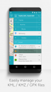
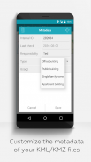
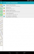
- KML/KMZ/GPX 파일 가져오기, 편집 및 관리
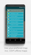
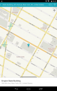
- 오프라인 지도: OpenStreetMap, OpenTopoMap, OpenCycleMap, 위성, 하이브리드 지도
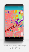
- 자체 데이터 세트 및 OpenData에 대한 웹 지도 서비스(WMS) 지원
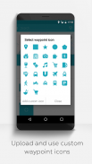
- 사진 매핑: 이미지를 지리적으로 할당
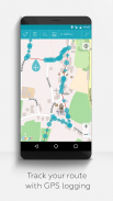
- 트랙 기록 및 분석
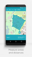
- 거리 및 면적 측정
- 여러 지도 레이어 동시 표시
- 대용량 데이터를 위한 계층적 폴더 구조
- 다국어 지원(영어, 독일어, 스페인어 등)
MAPinr의 장점:
- 광고 없음 및 데이터 안전: 백그라운드 서비스 없음, 추적기 없음, 데이터 수집 없음
- 비영리 개발: 사용자 데이터가 아닌 자발적인 기부금으로 운영
- 이전 Android 버전과 호환:
Android 12 이하 기기의 경우, farming.software에서 직접 자체 버전을 제공합니다.
MAPinr은 누구를 위해 만들어졌나요?
- 야외 스포츠: 하이킹, 사이클링, 스키 투어, 트레킹
- 전문가용: 측량, 환경 모니터링
- 개인정보 보호에 민감한 사용자
- 소규모 농업, 퍼머컬처, 혼농림업, 시장형 원예, 취미 정원 가꾸기
________________________________________
건설적인 피드백을 환영합니다.
MAPinr은 사용자와의 소통을 중시합니다.
제안, 질문 또는 오류 메시지가 있으시면 mapinr@farming.software로 직접 문의해 주세요.
앱 개선에 도움을 주세요.
- 건설적인 피드백은 댓글 없이 나쁜 평가를 내리는 것보다 훨씬 소중합니다.
- 기기, Android 버전, 그리고 문제에 대한 간략한 설명을 포함한 오류 보고는 저희가 개선하는 데 도움이 됩니다.
- 기능 요청의 실현 가능성과 커뮤니티 관련성을 확인합니다.
리소스는 제한적이지만, 합리적인 제안과 개선 사항을 정기적으로 반영하기 위해 노력하고 있습니다. 비판은 저희가 이해할 때만 도움이 됩니다. 공정하게 평가해 주세요.


MAPinr - KML/KMZ/OFFLINE/GIS - APK 정보
APK 버전: 4.2.3패키지: at.xylem.mapinMAPinr - KML/KMZ/OFFLINE/GIS의 최신 버전
다른 버전들


동일 카테고리의 앱


